Original Rootsweb Co. Tyrone Community Site
History of Land Ownership around Killeter, Termonamongan Parish from the Middle Ages to the Land Reform of 1931
Land Ownership Prior to English
Rule of County Tyrone
(click here for Appendices viewable as a pdf)
Webmaster's Note:
Bob Simon is an American descendant of the Dolan family of the region around Killeter, County Tyrone. His great-grandfather was born there in the 1850s and his great-great-grandparents, John and Margaret (née McKane) Dolan, are buried in St. Patrick's RC Church cemetery in Aghyaran. His research into the lands that they farmed as tenants in Seegronan Townland led him to write this more general history of land ownership in Termonamongan Parish. Bob's research on the Dolan families of Termonamongan Parish can be found at his website
Simon,
Hurd, Dolan, and Related Families. He would welcome additional information on the topics covered in the paper at robertmsimon@gmail.com.
Termon Land
As is suggested by its name,
Termonamongan parish was historically termon land – a class of land that was
dedicated to the maintenance of a church or monastic establishment, that had
by right the privilege of sanctuary, and that was free from the owing of any
rents or other exactions by a temporal lord. The connection between termon
land and the right of sanctuary from one’s assailants is especially strong.
While the word “termon” is thought to come originally from the Latin word
“terminus,” meaning “boundary” (a reference to the fact that the boundary of
such lands where sanctuary applied had to be marked, generally with stones),
the Irish word for “sanctuary” or “place of refuge” is “tearmann.”
An early account of the origin of
these lands was given by Irish clan leaders in 1609 to a set of royally
appointed “Commissioners for the Plantation in Ulster” who were, in part,
investigating the ownership of termon lands. These clan leaders testified
that termon lands were originally granted, in perpetuity, by the temporal
lords of their localities to hermits and other religious persons who had
settled in those places and built churches or other shrines,
“to the intente that the said religious persons should maintain
hospitalitie, praie for the soules’ health of the said lords, and repaire
and keepe the said churches, and otherwise advance the service of God in
that place, whereon hee lived….”
As described further by the clan
leaders, these religious persons, in turn, chose a local leader and his
kinship group (whether a clan or a branch of a clan known as a sept) to whom
they gave the termon land, to be maintained and used to continue the
religious purposes for which it had been granted.
The ownership of land within termons
was governed by customary Gaelic law, known as brehon law. Under brehon law,
property rights were not vested in an individual, but in the extended
kinship group. For this reason, property rights in the clan or sept were
inherently temporary and subject to periodic redistribution through two
practices. Under one practice, known as gavelkind, all male members of the
clan were entitled to farm equal portions of the clan’s land, regardless of
whether they were legitimate or illegitimate sons. Under the other practice,
known as tanistry, the position of chief within the kinship group, along
with his control over the group’s lands, passed at the chief’s death not to
his son but to an heir-apparent previously chosen by the group from among
the leading men in a broader circle of his relatives.
Termons functioned under the
leadership of lay ecclesiastics from the same clan or sept designated by the
saint or holy person who founded the religious site. For more prominent
religious sites, these chiefs were known as coarbs, from the Irish
“comharba” (which means “successor”), indicating that they were considered
the spiritual successor of the saint or holy person. For smaller church
sites, these chiefs were known as erenaghs, from the Irish “airchinneach”
(which means “superior”),
a term that originally was used to describe the head of an early Irish
semi-monastic community.
Coarbs and erenaghs were selected
according to brehon law, as described by the testimony to the 1609
Commissioners:
“…the corbe [i.e., coarb] and herenagh [i.e., erenagh] was ever to be
elected by the sept among themselves, and was commonlie the ancientest of
the sept….”
In some cases, coarbs served in a
hierarchical role over one or more erenaghs, as described to the
Commissioners:
“…the corbe, in many places, hath under him one or more herenaghes to whom
he giveth a portion of the land free, or for rent or customes, and other
liberties as he saw fit….”
Coarbs and erenaghs combined their
roles in managing the kinship group’s lands under brehon law with their
leadership in terms of maintaining the church or sacred site. This included
providing hospitality to pilgrims travelling through the lands.
Coarb and erenagh families were also a source of clerical leadership for
their territories by supplying family members who would serve as priests.
Termon Davog
Evidence may be found for a very
early establishment of the Catholic church in Termonamongan parish in the
form of a square-shaped iron bell, coated with bronze, that is now in the
National Museum of Scotland, Edinburgh, and that is labelled as being from
Termon Moncan, Lough Derg.
While the date of the bell is not established, it appears to be from before
the ninth century.
In the 11th century, the land that is now part of Termonamongan parish was
part of Termon Davog, a pocket of church land located between the kingdoms
of the O’Donnells, the O’Neills, and Maguires of Tyrconnell, Tyrone, and
Fermanagh. The termon belonged to the monastery on Saint’s Island in Lough
Derg,
and was named for St. Davog, the first abbot of the monastery.
The Catholic Church in Ireland was
reformed and diocesan boundaries established at the Synod of Rath Breasail
in 1111. In Ulster, these boundaries were defined in somewhat general terms,
and proved fluid over the next few decades. During this time, the lands in
Termon Davog were split between two dioceses–with the western lands around
Lough Derg becoming part of the Diocese of Clogher and the eastern lands
eventually becoming part of the Diocese of Derry.
The struggle for dominance between different branches of Cineál Eoghain (the
dominant clan of Ulster, whose chief family was the O’Neills) in the parts
of northern Ireland encompassing the eastern and western portions of Termon
Davog may explain why episcopal jurisdiction over these lands were split.
Notwithstanding this split in
episcopal territory in the 12th century, the lands of Termon Davog in the
13th century seem to have been under the sway of Clan McGrath, the heads of
which served as the coarbs of Lough Derg. The first mention of the McGraths
in this role as coarbs is in an entry in the Annals of Ulster from
1290, recording that “Gilla-Adomhnain Magraith, superior of Termonn-Dabeoig,
rested on the 13th of the Kalends of November” (i.e., he died on this date).
The land in the eastern part of
Termon Davog was served by the church of St.
Caireall (in
Irish, Cill Cairill). This may be the church that originally housed the
church bell described above.
A picture of the remains of its foundations is in Figure 1. St. Caireall’s
Church is mentioned in a taxation list for the Diocese of Derry from about
1300, under the name of Kelkirell.
A later rental roll for the Diocese of Derry from October 1397 lists it
under the name of Kylchyrryll.
By the early 1400s, the erenagh
family of the O’Mongans was associated with this church; and this family
gave its name to Termonamongan parish,
as well as to Ballymongan and Trienamongan Townlands, which were given to
members of this erenagh family for their use.
Termonamongan hosted two prominent way stations on the pilgrimage route to
Lough Derg—St. Patrick’s Well in Magherakeel and St. Davog’s Well in
Crighdenis.
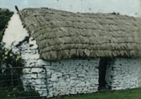
Figure 1. Ruins of St. Caireall’s
Church, as seen from Magherakeel Graveyard, outside Killeter, (photograph to
right) and picture of what the church might have looked like (photograph
to the left). In the photograph to the right, the remains of the church walls are
on the right. On the left side of the picture is the former Magherakeel
National School, built much later, perhaps using some of the stones from the
former church.
(Photograph on
right by Robert M. Simon, 2016; photograph on left from the historical
marker on the site.)
The development of a diocesan
structure in the Catholic church in Ireland was accompanied by the assertion
of a degree of control by local bishops over termon lands. As described by
the testimony to the 1609 Commissioners, over time, bishops took on the
power to confirm new coarbs and erenaghs selected by their sept, and if the
sept could not agree, then the bishop and the clergy of his diocese would
elect one of the members of the sept to the position. In addition, if a sept
became extinct, the bishop (again in consultation with the clergy of his
diocese) could choose another sept that would provide a new coarb or erenagh
to inherit and administer the termon lands.
Coarbs and erenaghs thus served as
the bishop’s chief tenants over the other hereditary tenants of these lands.
As the above-mentioned taxation and rental rolls indicate, St. Caireall’s
Church made rental and other payments to the bishop of Derry, similar to the
other churches in the Diocese of Derry. In the area around the Dioceses of
Derry and Raphoe, the system of dividing the tithes produced from the termon
lands and their tenants initially involved giving a one-third share to the
local rector of the parish, one-third to the vicar, and a final third to the
Bishop. But as the payment of the tithes was often in kind, the Bishop’s
third was hard, in practice, to collect. For this reason, the system evolved
to one in which the erenagh was given the final “Bishop’s third,” and then
was responsible for paying an annual pension to the Bishop, making him, to
some degree, the Bishop’s ordinary collection agent.
Land Ownership as English Rule
Came to Be Established in County Tyrone
McGrath Ownership of Lands of
Termon Davog
Coarb and erenagh families held title
to their termon lands under brehon law, but English common law had a
fundamentally different concept of property, founded on the rights of an
individual, rather than of a kinship group. Under English common law, it is
the individual who is vested with a variety of property interests and
rights, including fee-simple estates and leaseholds.
As part of its attempts to transform Irish patterns of land ownership into
patterns closer to English practice, the English government in Ireland in
the 1500s developed a policy of “surrender and re-grant,” by which Irish
chieftains would surrender their lordships to the English government, in
exchange for a royal grant of a heritable estate valid under English law.
Several leading members of the Irish nobility did so in the 1540s, notably
Conn O’Neill, who was granted (in addition to his estates) the title of Earl
of Tyrone.
For Termonamongan parish, this
process occurred in 1596, when Donoghoe McGrath, the coarb of Lough Derg,
surrendered his lands in Termonmagrath and Termonamongan to Queen Elizabeth
of England, in exchange for those same lands being re-granted in perpetuity
to him and his descendants. This transaction was probably engineered by
Donoghoe’s son, Miler McGrath, who was first a Catholic bishop in Ireland
but then joined the Anglican Church and held several Anglican sees in
Ireland during his life, notably the archbishopric of Cashel. Miler McGrath
was a colorful figure who travelled between Ireland and England, was a
favorite of Queen Elizabeth’s,
and was named in the grant to Donoghoe McGrath as his primary heir for the
grant. The transaction was recorded in two writs for letters patent (or
fiants) that were issued in Dublin on Queen Elizabeth’s behalf in 1596 – one
for the surrender of lands
and the other for the new royal grant.
Boundaries of the McGrath Grants
in Termonamongan Parish
Both fiants enumerate the boundaries
of the land being surrendered and re-granted, as well as place names of
locations contained within those boundaries. While many of the place names
mentioned are now no longer in use, there are several indications that the
lands covered by the surrender and re-grant extended to include Killeter.
The eastern extent of the termon
lands in question is identified as “Corragh Rooe in the east” (in the
surrender) and “Coreagh Roe in the east” (in the royal grant). This
description of the eastern extent of the grant was called “Curraghroe in the
east of Termon-Imonghan” in a 1610 re-grant of these lands to the grandson
of Donaghoe McGrath (discussed below).
While
Curraghroe is not a modern place name, two places in County Tyrone named
Curraghroe are depicted in a map of County Tyrone produced as part of the
1656-1658 Down Survey of Ireland. The map was published sometime between
1660-1675 in a book entitled Hibernia Delineatio,
and may be viewed on the Down Survey website of Trinity College Dublin.
Figure 2 shows an extract of that map.
In the figure, the Curraghroe
mentioned in the grants to the McGraths is most likely the one in the
center-right of the figure – just east of the southward U-shaped bend in the
River Derg that occurs before the river extends in a line northeast towards
Castlederg (labelled “C. Derge” in the figure). This location appears to be
in the present-day townland of Woodside outside Killeter.
This location is deemed
most likely because both Elizabethan writs also mention “Killcairll” (or St.
Caireall’s Church) and an identifiable townland outside Killeter, “Saie O
Gronayn” (or Seegronan).
Both of these locations would have been outside the boundaries of the grant
if “Curraghroe” meant the mountain to the west of both St. Caireall’s Church
(which is also shown in Figure 2, just below the label for “Magherekill”)
and Seegronan Townland.
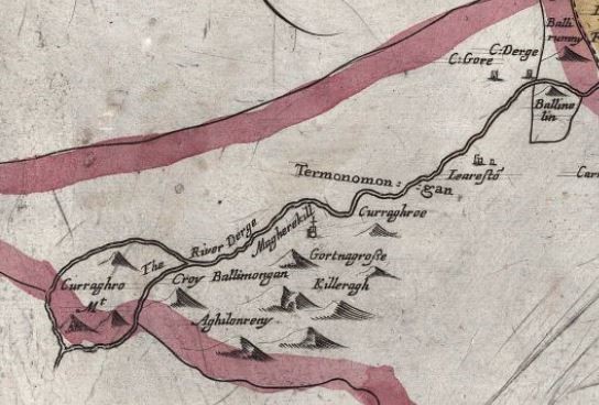
Figure 2. Termonamongan parish, circa
1660, detail from Down Survey county map for County Tyrone. From Reference
�34�.
While the two fiants from 1596
identify the church in Termonamongan Parish by the Irish name-equivalent of
St. Caireall’s Church, a 1607 preliminary survey of the Diocese of Derry by
Anglican Bishop George Montgomery identifies this church as “Sti. Beotis”
(or St. Bestius).
Bishop Montgomery’s 1607 survey is considered an accurate depiction of the
Catholic Church in the Diocese of Derry prior to the changes that attended
the implementation of the Protestant Reformation.
For this reason, it appears that the change in the identity of the patron
saint of the church in Termonamongan occurred prior to the re-organization
and assignment of parishes in the Derry diocese to the Anglican church.
Termonamongan Parish During the
Seventeenth Century
The Flight of the Earls
Of course, what the government of
England could give, it could also take away, particularly if the recipient
of a royal grant, or his heir, engaged in acts of rebellion. In that case,
the lands granted as part of a “surrender and re-grant” were forfeited to
the Crown, which could then grant the confiscated lands anew to others. This
occurred on a grand scale in Ulster at the beginning of the seventeenth
century.
From 1594 to 1603, the Irish and the
English fought the Nine Years War, caused in part by continued efforts by
the English government to project its power and authority into Ulster.
During the latter stages of the war, a series of royal garrisons were
planted in Ulster while a scorched-earth campaign of starvation and
extermination led to the reported deaths of tens of thousands in rebel-held
territories. The imminent death of Queen Elizabeth I in 1603, along with the
prospect that the next ruler of England (James I) would seek a different
policy towards the leading figures in Ulster (including Hugh O’Neill, the
Earl of Tyrone), resulted in the negotiation of a treaty to end hostilities.
King James began his reign by
pardoning the key Ulster leaders in the Nine Years War. Despite this, his
Crown officials in Ireland, led by Arthur Chichester (Lord Deputy of
Ireland—the senior Crown official) and John Davies (Solicitor General and
later Attorney General for Ireland), adopted provocative tactics—using legal
challenges and novel uses of the courts to seize for the crown and
distribute to freeholders large parts of the territories of the northern
earls.
This created new discord and deep suspicion on the part of the earls.
Around the same time, King James
appointed a new bishop, George Montgomery, to fill three vacant bishoprics
in northern Ireland—Derry, Raphoe, and Clogher. Montgomery was a court
favorite of King James. While the new bishop appears to have been somewhat
indifferent as a spiritual leader for his dioceses—indeed, he lingered in
England for a period of over 18 months after his appointment in 1605 before
heading to Ireland—once
in Ireland he developed a keen interest in putting the dioceses (and their
bishop) on a firm financial footing by laying claim to as many of the
Church’s traditional endowments as possible.
He initiated lawsuits with several key members of the traditional nobility
in Ulster to dispossess them of lands he claimed were church lands. This
further exacerbated tensions between the English and the native Irish
nobility.
Ultimately, two key northern earls
(the Earl of Tyrone and the Earl of Tyrconnell) became persuaded that their
best course of action was to leave Ireland and seek a personal conference
with King Phillip II of Spain, in hopes that he might agree to help them rid
Ireland of English influence. These earls, along with members of their
families and close associates, departed Ulster by ship on September 14,
1607. Although they had the intention of returning in force to Ulster, once
the earls were on the continent of Europe, they found little practical
support from the French or Spanish for such a return.
The “Flight of the Earls” and a
subsequent abortive rebellion in the region around Derry by Cahir O’Doherty
(both of which allowed the English government to declare the leaders
attainted and to confiscate their holdings) created a power vacuum in
Ulster. This enabled England to proceed with its plans to expand its
influence and prevent future rebellions in this part of Ireland.
The Plantation of Ulster
For decades prior to the Flight of
the Earls, the English had pursued a policy, further south in Ireland, of
importing English settlers to create a buffer of loyal inhabitants who would
support English rule. In the aftermath of the Flight of the Earls, and the
opening it provided for massive confiscation of land by the Crown in Ulster,
Arthur Chichester and his associates lost no time in traveling to Ulster to
survey the confiscated lands, to conduct trials of the absent and presumed
traitorous earls, and to confirm the attainder of O’Doherty.
Chichester and Davies also began
planning (in concert with the government in London) for the transfer of the
King’s vast new lands in Ulster to three classes of landowners:
“undertakers” from England and Scotland who would be given land that they
would undertake to own and manage, “servitors” who were veterans of the Nine
Years War and had been promised land in exchange for their services to the
Crown in the war, and “natives of Ireland” who were deemed trustworthy by
the English.
Land was to be allocated to these new landowners in “reasonable portions”
(i.e., on the order of 1,000 to 2,000 acres) on the theory that this would
be a more effective means of settling the land than granting huge estates
(e.g., 100,000 acres) to nobles who would not have the same interest in
managing and improving the land.
In addition, landowners would be grouped locally to provide support to one
another, with some districts being assigned to English undertakers and
others to Scottish undertakers.
The initial survey of Ulster was not
of sufficient quality to be used to assign portions of land to the many
interested claimants, and a further survey was undertaken in 1609 by a set
of “Commissioners for the Plantation in Ulster,” with an additional focus on
resolving the question of which lands had been forfeited to the King by the
events of the preceding years and which were owned by the Church. The
Commissioners responsible for conducting these surveys and inquiries into
land ownership included representatives of the Anglican Church in Ireland,
notably (for the survey of lands in his dioceses) Bishop Montgomery.
They took testimony from clan and sept leaders in several locations in
Ulster (including the testimony on termon lands quoted earlier in this
paper). The Commissioners concluded that, while the Anglican Church was
entitled to lands directly owned by the church in Ulster, the termon lands
were appropriately considered to have belonged to coarbs and erenaghs who
were subservient to the Irish earls, and therefore were included in the
secular lands that were forfeited to the Crown.
Despite this decision in favor of the
Crown, Bishop Montgomery employed his influence with the King to obtain a
different result for these termon lands, and the King and his Privy Council
in London accordingly “resolved (albeit that they were not found to be the
bishops’ lands but the King’s), that the bishops should have those lands
entirely, as of his Majesty’s free donation….”
The grant by the King to the bishops included a total of 32,280 acres to
Bishop Montgomery across all three of his bishoprics in Ulster, including
27,280 acres in County Tyrone.
The Anglican Church and Ownership
over Lands in Termon Davog
The extensive grant of termon lands
to Bishop Montgomery, however, did not include the lands of Termon Davog,
including both Termon McGrath and Termonamongan parish. During the work of
the Commissioners in 1609 near Lough Erne in County Fermanagh, a dispute
arose between the Bishop Montgomery (who was interested in Termon McGrath in
his role as Bishop of Clogher and Termonamongan in his role as Bishop of
Derry) and Archbishop Miler McGrath concerning these lands. Archbishop
McGrath cited the royal grant of these lands to his father (who apparently
had not been attainted), and King James was not willing to revoke the
Elizabethan grant. Thus, the initial attempt to acquire these lands for the
Diocese of Derry was thwarted.
The Second Royal Grant to the
McGrath Family
Not only was this first attempt by
the Anglican Church to acquire title to the lands of Termon Davog
unsuccessful, on December 22, 1610, King James I issued a fresh grant of the
lands of “Termon Magrath” and “Termon Imoghan” to James McGrath.
James McGrath was the fifth son of Archbishop Miler McGrath, who was still
living at the time. James had also been named as one of the successors in
interest to the Archbishop in the Elizabethan grant of 1596.
The bounds of the new grant were identical (except for the spelling of place
names) to the boundaries described in the previous Elizabethan grant. The
grants also included several new authorities for James McGrath, like those
provided to English and Scottish undertakers receiving grants at the same
time elsewhere in Ulster. These included powers to subdivide the grant into
“precincts of 1000 [acres] each at the least, and to impose distinct names
thereon, that each may become a manor,” to build a “capital house,” to hold
a “saturday market” and two fairs each year, and to receive a “moiety of
felons’ and fugitives’ goods.”
The authorization for a “capital house” probably allowed the construction of
Castle McGrath, which was built in 1611 by James McGrath on the Termon
McGrath lands close to Lough Erne.
Notwithstanding the renewed grant of
lands in Termonamongan parish to James McGrath, the Diocese of Derry
continued to assert that it owned these lands. This is evidenced by a
statement in a document entitled “The Estate of the Diocess of Derry,”
compiled by George Downham, Bishop of Derry from 1616-1634, drawing from a
manuscript entitled “The Ulster Visitation Book – 1622.”
In Part V of the document, it is stated that “In the parish of
Termonamongan, the tithes of seven sessioghs [were] detained from the
Incumbent by James McCraugh under pretence that they were Abbey Lands, being
indeed (as they will most clearly be proved) the lands of the Bpp. Of
Derry.”
The “James McCraugh” in this complaint is almost certainly James McGrath,
whose claim of “Abbey lands” was probably an assertion of his right to the
former termon lands.
The weakness of the Diocese of
Derry’s claim, at this point, to the land of Termonamongan parish may also
be evidenced by the fact that no glebe land had been set aside in
Termonamongan parish as of 1622,
in contrast to other places in the Diocese where lands were turned over to
the Diocese and it could make provision for glebe lands from its endowment.
Royal Grant of Other Lands in
Termonamongan Parish to John Davies
As Attorney General for Ireland, John
Davies had traveled extensively around the island, including throughout
Ulster. He apparently viewed County Tyrone as a desirable locale for him to
acquire land. Within County Tyrone, the Barony of Omagh had been set aside
for English undertakers.
John Davies and several of his relatives by marriage
ended up monopolizing the royal land grants in that Barony. Davies himself
received two proportions in this Barony. One was in the area around what is
now Drumquin. The other proportion was an area partly in Termonamongan
parish, around what is now Castlederg, in an area characterized as
“Gravetagh” and which included the areas in Table 1.
While the total amount of acres in this proportion was given as 1,000 acres,
it should be noted that the acreage numbers in the original royal grants in
Ulster only represented “arable land” and did not include vast amounts of
so-called “unprofitable” land (which in many cases turned out to be very
profitable for pasturage), bogs, and woodland.
In fact, the Barony of Omagh was represented as having only 11,000 acres of
land grants to John Davies and his relatives, while the accompanying map
depicted them being granted nearly the entire area of the barony, which was
over 224,000 acres.
Table 1. Areas in Gravetagh granted
to John Davies in 1610.
Names of probable or potential modern-day equivalents given in second
column, where apparent.
|
Area
Named in Description of “Gravetagh”
|
Current
Name
|
Current
Parish
|
|
Ballichandrin
|
|
|
|
Ballinchavan
|
|
|
|
Kilchlin
|
Kilclean
|
Urney
|
|
Lisnaclony
|
Lisnacloon
|
Termonamongan
|
|
Castlannadergy
|
Castlederg
|
Urney
|
|
Nerebulrewy
|
|
|
|
Aghacoran
|
Aghyaran
|
Termonamongan
|
|
Letrim
|
Leitrim
|
Termonamongan
|
|
Kisalahard
|
|
|
|
Magherynagheragh
|
Magheranageeragh
|
Termonamongan
|
|
Lisaline
|
Lisleen
|
Ardstraw
|
|
Gravetagh
|
Garvetagh
|
Ardstraw
|
|
Kilbovill
|
|
|
|
Mollyvrestlan
|
Mullanabreen?
|
Termonamongan
|
|
Ardvaran
|
Ardarver
|
Termonamongan
|
|
Dromnois
|
Dreenan?
|
Termonamongan
|
|
Molanavare
|
|
|
Cartography of Land Holdings in
Termonamongan Parish Around 1609
A map
executed around 1609 by John Norden, and perhaps intended as a guide to
planned distribution of land in Ulster, is in the British Library.
A detail from this map for the western part of County Tyrone and surrounding
areas is shown in Figure 3. The map shows both the lands granted in “Termon
Magraghe” to James McGrath as well as the holdings of John Davies (including
“Grauetagh”) and his brother-in-law, Mervyn Audley. The map is thought to be
based on a survey by Josias Bodley, which did not involve measurements on
the ground and which relied on information gathered from local inhabitants.
While it is not a map drawn to scale, it does show the extent of Termon
McGrath, including lands in Termonamongan parish.
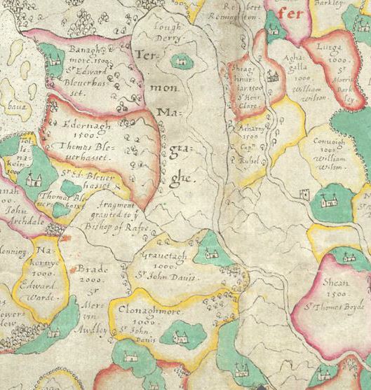
Figure 3. Detail of map of Ulster by
John Norden, 1609, showing the division of lands in Termonamongan Parish
between the holdings of James McGrath and John Davies. In this map, the top
of the map points West. From Reference �64�.
Mid-Century Ownership of Land in
Termonamongan Parish
As the seventeenth century unfolded,
tensions between the English and Irish continued to grow,
culminating in the Irish Rebellion of
1641, which broke out first in Ulster and then spread throughout Ireland.
During the time before and after the Irish Rebellion, surveys were
undertaken by the English authorities to investigate and record land
ownership in Ireland, with a view to facilitating additional Protestant
settlement. These results were compiled in various Books of Survey and
Distribution from 1641 to 1680.
Perhaps the most complete of these surveys was the Down Survey, undertaken
from 1656 to 1658. Trinity College Dublin has integrated the maps from the
Down Survey with lists of landowners from 1641 and 1670 taken from other
Books of Survey and Distribution of that era to create a geo-referenced
dataset, searchable on a dedicated website (hereafter referred to as the
Down Survey website), that can be used to identify patterns of land transfer
during and after the Irish Rebellion.
Lands Originally Granted to James
McGrath
The Down Survey website shows that by
1641, the lands in Termonamongan parish that had been granted to James
McGrath in 1610 were owned by the Anglican Church (which leased those lands
to another “English Protestant,” Dean Wilson). This means that the Diocese
of Derry had regained possession of the lands of Termonamongan parish from
James McGrath before 1641.
The Down Survey website also shows
that James McGrath continued to own lands in Termon McGrath in County
Donegal in 1641. It is not clear why McGrath had lost some lands by 1641 and
not others. Perhaps there was a continued push to acquire these lands by the
Bishops of Derry that was more successful than that of the Bishops of
Clogher, who would have had jurisdiction over the area in County Donegal
where Termon Magrath was located.
The geographic information system
(GIS) layer of the Down Survey website describes several present-day
townlands in Termonamongan parish (Killeter, Gortnagross, Magherakeel,
Aghalunny, and Ballymongan) as being owned by Dean Wilson in both 1641 and
1670,
but this is not entirely accurate, on two accounts, as is shown by the map
and terrier from the Down Survey reproduced in Figure 4 and Figure 5,
respectively.
The Down
Survey produced maps of parishes where land forfeitures had occurred,
accompanied by “terriers,” which were textual descriptions of the lands and
the persons associated with them. Termonamongan parish was one of those
parishes. While the original map from the Down Survey was destroyed in the
Custom House Fire in 1922, a copy made by Daniel O’Brien in 1786 was
preserved, is now in the Public Record Office of Northern Ireland (PRONI),
and is available through the Down Survey website.
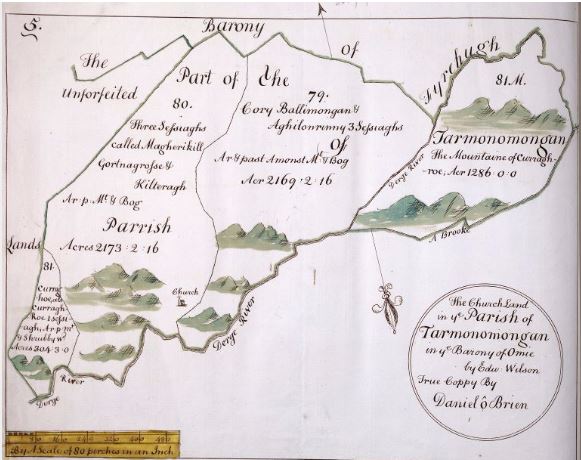
Figure 4. Down Survey map of
Termonamongan Parish. 1786 Copy by Daniel O’Brien. From Reference �68�.
The map in Figure 4 shows the lands,
oriented with South to the top of the page. The description of the lands is
instructive—they are characterized as church land, and not escheated land.
Thus, the actual owner of the lands was not Dean Wilson,
but
the Anglican Church (i.e., the Anglican Diocese of Derry). This is confirmed
by the terrier in Figure 5, which repeats the description of the map as
“being Church Land” and describes “Deane Wilson” as a “Leasee.”
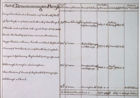
Figure 5. Terrier (or textual
explanation) accompanying the Down Survey map of Termonamongan Parish. 1786
Copy by Daniel O'Brien. From Reference �68�.
The other major inaccuracy in the
Down Survey website consists of the extent of the lands held by the church
and leased to Dean Wilson. While the map in Figure 4 shows four major
divisions in the lease, each of the divisions contains many more townlands
than those that happen to form part of the division’s name, as can be seen
by the fact that the divisions extend to the boundary of the “Barony of
Tyrehugh” (i.e., the border with County Donegal).
Table 2
lists the townlands (from the 1859
Griffith’s Valuation of Tenements) that appear to be contained within each
of the divisions depicted in the map in Figure 4. As a check, the acreages
in the Down Survey map are compared to the acreages in Griffith’s Valuation
for the same lands. For this purpose, the definition of an acre in the Down
Survey is taken to be a traditional Irish acre (or plantation acre), which
is 1.62 times the size of a statute acre, the measure used in the Ordnance
Survey maps for Griffith’s Valuation.
The acreage statistics from the Down
Survey map, when compared to acreages in Griffith’s Valuation for the same
lands, are relatively close and perhaps as close as might be expected. The
definition of an acre in the seventeenth century varied from place to place,
and sometimes was tied to the quality of the land. (footnote 70) For this reason, as well as the greater difficulties in taking measurements in rough terrain, it is not surprising that the acreage measurements for church lands in Termonamongan parish are closest between the Down Survey and Griffith’s Valuation for the best parish land, closest to the River Derg, and at most variance for the mountainous land in the west of the parish.
The set of townlands shown in Table 2
persists as a unit that was leased or owned together as a block from the
date of the Down Survey map (around 1658) to the final distribution of the
land to incumbent tenants under land reform in 1931 (see list of townlands
in Appendix B, page 2).
Table 2. Termonamongan Parish
Townlands in Down Survey Parish Divisions.
Divisions from the Map of Tarmonomongan
parish accompanying the Down Survey (ca. 1658), compared to townlands listed
in the 1859 Griffith’s Valuation for Termonamongan parish. Acreage
statistics between the two roughly agree, and diverge most for mountainous
country in the west of the parish lands in the Down Survey.
|
Down Survey Map Division
|
Irish Acreage from Down
Survey Map
and
Statute Equivalents
|
Griffith’s Townlands in
Map Division
|
Acreage (Statute) from
Griffith's Valuation
|
|
|
A
|
R
|
P
|
|
A
|
R
|
P
|
|
Curraghoe, also
|
|
|
|
Crilly’s Hill
|
226
|
0
|
1
|
|
Curraghroe (81)
|
|
|
|
Glebe
|
48
|
3
|
0
|
|
|
304
|
3
|
0
|
Woodside
|
203
|
3
|
10
|
|
|
492
|
2
|
5
|
Total
|
478
|
2
|
11
|
|
Magherikill, Gortnagross,
|
|
|
|
Aghalougher
|
110
|
2
|
2
|
|
and Kilteragh (80)
|
|
|
|
Golundun Dolan
|
447
|
2
|
21
|
|
|
|
|
|
Golundun McHugh
|
538
|
3
|
4
|
|
|
|
|
|
Gortnagross
|
442
|
1
|
39
|
|
|
|
|
|
Killeter
|
427
|
3
|
29
|
|
|
|
|
|
Magherakeel
|
476
|
3
|
17
|
|
|
|
|
|
Meenamullan
|
629
|
2
|
31
|
|
|
|
|
|
Speerholme
|
163
|
0
|
16
|
|
|
2173
|
2
|
16
|
Seegronan
|
700
|
3
|
35
|
|
|
3521
|
0
|
37
|
Total
|
3937
|
3
|
34
|
|
Croy, Ballimongan, and
|
|
|
|
Aghalunny
|
403
|
1
|
6
|
|
Aghilonrinny (79)
|
|
|
|
Ballymongan
|
1172
|
3
|
37
|
|
|
|
|
|
Crighdenis
|
813
|
3
|
26
|
|
|
|
|
|
Crighshane
|
992
|
2
|
33
|
|
|
|
|
|
Shanaghy
|
324
|
0
|
17
|
|
|
2169
|
2
|
16
|
Tievenameenta
|
275
|
3
|
2
|
|
|
3514
|
3
|
0
|
Total
|
3982
|
3
|
1
|
|
Curraghroe Mountain
|
|
|
|
Athabryanmore
|
642
|
3
|
24
|
|
(81M)
|
|
|
|
Essan
|
630
|
3
|
15
|
|
|
|
|
|
Meenafergus
|
693
|
3
|
31
|
|
|
1286
|
0
|
0
|
Tulnashane
|
560
|
2
|
19
|
|
|
2083
|
1
|
11
|
Total
|
2528
|
1
|
9
|
|
Total Irish Acreage
|
5933
|
3
|
32
|
|
|
|
|
|
Total Statute Acreage
|
9613
|
0
|
0
|
Grand Total
|
10927
|
2
|
15
|
It is also
worth noting that the map in Figure 4 identifies the three eastern divisions
of church land in Termonamongan parish as comprising seven sessiaghs, the
same area of land from which Derry Bishop Downham had stated that James
McGrath was refusing to pay his share of tithes.
Lands Originally Granted to John
Davies
The Down Survey website also shows
changes in the status of the lands granted to John Davies in “Gravetagh” on
the eastern and northeastern borders of Termonamongan parish (and extending
into adjacent parishes). Davies outlived both his sons, and his relationship
with his wife was strained, to say the least, by her erratic behavior. For
this reason, he made his daughter Lucy Davies his sole heir. He had
previously arranged for Lucy to be married, at the age of 11, to Ferdinando
Hastings, the Sixth Earl of Huntingdon. Therefore, Lucy inherited all of
John Davies’s estates at his death in 1626, including lands granted to him
in Ireland by royal patent in 1609.
A separate Civil Survey conducted in 1654-1656 for Counties Donegal,
Londonderry, and Tyrone identified the sole proprietor for private holdings
in the “Parish of Tarmonomongan” as Lucy’s husband, “Ferdinando, Earle of
Huntington, English ptestant.”
The Down Survey website also names
the “Earl of Huntington” as the owner for many of the “Gravetagh” lands in
both 1641 and 1670,
but two different owners are involved. Ferdinando Hastings died in 1656 and
was succeeded by his son Theophilus Hastings (1650-1701), the seventh Earl
of Huntingdon. Therefore, the reference to the Earl in 1670 would be to
Theophilus. Both Earls were absentee landlords, as they were residents of
Leicestershire in England.
Land Restrictions by the End of
the Seventeenth Century
The original “Articles Concerning the
English and Scottish Undertakers,” issued at the beginning of the Plantation
of Ulster, restricted the English and Scottish colonists in Ulster from
selling or conveying any of their lands back to the “meer Irish.” This
prohibition gradually grew from a provision affecting Ulster to one that
would encompass all of Ireland, and after the war of 1690, the English
Parliament enacted a prohibition on the Irish purchasing, or even holding as
tenants, any quantity of land greater than two acres.
The Land Around Killeter During
the Eighteenth and Nineteenth Centuries
The Law and Practice Governing the
Lease of Church Lands
During the century between 1670 and
1770, the record of the administration of the Diocese of Derry’s lands
around Killeter is somewhat sparse. This is due to the destruction of many
civil and church records in the 1922 fire at the Public Record Office in
Dublin. What is known is that in the 1770s, the prime lessee of the Diocese
to the former termon lands in Termonamongan parish was not a lineal male
descendant of Dean Wilson, but Sir Patrick Hamilton (ca. 1730-1780).
How might have this lease been
transferred? To begin with, some background on leases of church lands is in
order.
At the time that King Henry VIII
seized church lands as part of the establishment of the Church of England, a
law was instituted that churches could not sell or alienate their lands, but
could grant leases for either (1) a term of up to 21 years or (2) a term of
“three lives.” The latter meant a lease naming three individuals and
extending to the end of the longest of those three lives. The 21-year leases
could be renewed at 7-year intervals—at which point another 7 years could be
added to the term of the lease. Leases for three lives could be effectively
renewed upon the death of one of the named individuals, by adding a new
person to the lease—someone much younger than the remaining two living
individuals.
In practice, both kinds of church
leases were managed in a way that involved the payment of nominal annual
rents (known as reserved rent), with the bulk of the funds due being paid at
the time of renewals, when the value of rents for the extended term was
calculated and paid in a lump sum to the church authority (a payment
popularly called the “fine”). Two important considerations provided the
incentive for this practice of managing church leases. For the lessee,
renewals before the term of the lease expired provided the prospect of
indefinite tenure, so long as he maintained cordial relations with his
lessor in anticipation of times when renewals could occur. For the lessor
(e.g., the Bishop), renewals provided a large lump sum representing several
future years of lease payments, and these renewal fines belonged absolutely
to the lessor for his benefit and that of his family. Most Bishops found
collecting fines at renewal times preferable to waiting for the end of
21-year term of a church lease (or the demise of the longest-lived
individual on a lease for three lives), by which time the Bishop might have
died or been moved to some other diocese.
Lease of Church Lands in
Termonamongan Parish by the Hamilton Family
The family of which Sir Patrick
Hamilton was a member was prominent among the ruling class in County Tyrone
in the 1600s and 1700s. His great-great-grandfather, William Hamilton, was a
distant relative of James Hamilton, the first Earl of Abercorn.
The first Earl of Abercorn was a promoter of the Plantation in Ulster who
received a royal grant of a large estate from escheated lands in County
Tyrone after the Flight of the Earls.
William Hamilton came from
Priestfield, Scotland and settled in Ballyfatton, Urney parish, County
Tyrone in 1616. In 1634, he was granted title for the lands on which he had
settled. He died in 1642 as a prisoner of the Irish during the Rebellion of
1641.
He had two sons. His younger son, also named William Hamilton, eventually
took possession of Ballyfatton. This second William Hamilton had 13
children, the eighth of whom settled in Killeter and was known as Patrick
Hamilton of Killeter.
Patrick Hamilton of Killeter was an
attorney-in-law. He was admitted to the Honourable Society of King’s Inns in
Dublin, Ireland’s oldest school of law, in 1671, suggesting a birth around
1650. He married Jane Newburgh in 1667. Jane was one of three daughters and
co-heirs of Arthur Newburgh, High Sheriff of Tyrone. Jane’s mother was Ann
Newburgh (née Downham), one of the daughters and co-heirs of James Downham,
Dean of the Diocese of Armagh, and her grandfather was William Downham, who
had been Bishop of Derry from 1617 to 1634.
Although no documentary evidence has
been found to date that the leases in Termonamongan parish were transferred
to Patrick Hamilton, with the sort of church connections brought to him by
his marriage, it is possible to see how the Diocese of Derry might have
favored him with a lease to the lands in Termonamongan parish, if it were
available. It is also possible that the lease rights came to him through his
wife, Jane Newburgh. Everard Hamilton refers to lands in Termonamongan,
County Tyrone, being mentioned in the will of Anne Newburgh, Jane’s mother,
which was proved on May 28, 1712.
It was around this time that the
Anglican Church in Termonamongan parish (St. Bestius) finally was awarded
glebe land, carved out from the lands of the Diocese of Derry next to the
church, and made a separate townland (called, not surprisingly, “Glebe”).
Patrick Hamilton of Killeter and his
wife Jane had 8 children, the oldest of whom was the Rev. William Hamilton,
born about 1683 in Dublin.
The Rev. William Hamilton was appointed Rector in Termonamongan parish on
August 8, 1716, and served in this and a concurrent position in another
parish until his death on May 26, 1765.
He was succeeded as Rector of Termonamongan parish by his son-in-law, Adam
Harvey,
who served there from 1765 to 1771.
The third child of Rev. William
Hamilton was Sir Patrick Hamilton. As of the 1770s, he held the lease from
the Diocese of Derry for its lands in Termonamongan parish. A 1774 letter
written to Bishop Frederick Augustus Hervey of Derry by the Rev. Matthew
Galbraith, Rector of Termonamongan parish,
characterizes the inhabitants around Killeter as “Sir Patrick’s tenants.”
Rev. Galbraith’s letter is reproduced
in Appendix A, and contains responses to a series of questions and
suggestions by Bishop Hervey regarding the improved management of the church
lands in Termonamongan parish. Some of the responses describe the
difficulties faced by the Irish tenants on these lands. Rev. Galbraith notes
that Sir Patrick’s local agent was less than helpful in providing
information to answer the questions, so the inquiry appears to be a case of
the Bishop going behind the back of his lessee to ascertain the state of
payments of rentals and options for improving the land. This suggests that
Sir Patrick may have been disengaged from the day-to-day management of the
lands. Sir Patrick may not even have been a resident of Killeter during his
time as the Bishop’s lessee (which made him the lessor to the tenant
farmers)—he served as Alderman and Mayor of Dublin in 1760 and he died at
Twickenham, outside London, in 1780.
Sir Patrick died without children and
his older brother, Thomas Hamilton, may have assumed the lease rights to the
church lands in Termonamongan parish. Thomas had moved from County Tyrone
and was resident both in Annesbrook (in County Meath) and Dorset Street and
Leeson Street (in Dublin). He died in 1792 and his will was proved on
October 24, 1792. Thomas’s will must have dealt in some fashion with the
lands in Termonamongan parish, since the Hamilton Memoirs note that
Thomas’s son, Rev. William Slicer Hamilton (also of Annesbrook), entered
into a “deed of mutual agreement” with Thomas’s widow on December 13, 1792,
relating, among other things, to lands in Termonamongan, County Tyrone.
Lease of Church Lands in
Termonamongan Parish by the Smith Family
Sometime before 1857, the Rev.
William S. Hamilton assigned his rights to the lease of the areas around to
Killeter to Henry Jeremiah Smith of Annesbrook in County Meath.
It is logical to assume, since both parties were living in Annesbrook, that
they were known to each other and that their acquaintance played a role in
the transfer of the leases to Smith. The assignment of these rights could
have taken place as far back as the period from 1803 to 1831, as a 1931
Abstract of Title for the lands mentions a lease agreement between Henry
Jeremiah Smith and “the late William Lord Bishop of Derry,”
who would have been Bishop William Knox.
On February 3, 1857, Henry Jeremiah
Smith wrote a will addressing his interests in and around Killeter. A copy
of the text of his will is in Appendix C. In the will, he appointed trustees
over these land interests—Hugh Montgomery (his son-in-law) and St. George
William Smith (the second son of his second marriage). Henry Jeremiah Smith
had decided that his primary heir for these land interests would be
Frederick Augustus Smith, who was the sixth son of his second marriage.
His will then laid out a complex series of contingent successors in
interest, should Frederick Augustus Smith not have male heirs, including (in
this order) his sons Stephen Henry Smith, St. George William Smith, Michael
Edward Smith, and William Thomas Smith, with control of the land passing to
the next son, if the previous son in the list died leaving no lawful male
heirs.
Henry Jeremiah Smith died on February
15, 1857 and his will was submitted for probate on March 26, 1857.
Frederick Augustus Smith then became the lessor of the lands around Killeter
under the existing lease from the Diocese of Derry and Raphoe (the two
dioceses having merged in 1834). He must have engaged his brother Michael in
the management of these lands, as both Michael and Frederick Smith are named
as the lessors of these lands in the 1859 Griffith’s Valuation for this part
of County Tyrone.
It appears that the Smiths were also
absentee landlords. A news story published in the Morning News
(Belfast) on October 9, 1862, describes a visit by Michael Smith and a
nephew to his Killeter estate and gives his residence as Newcastle,
Staffordshire, England.
An entry in Burke’s Landed Gentry of Ireland, 1899, identifies his
residence as Lansdowne Crescent in the West End of London.
The 1862 news story indicates that Michael Smith had visited Killeter before
and had exhibited “friendship and kindness to all, and liberality to the
poor,” so he may have enjoyed some popularity as a landowner. It is
difficult to be certain of the sentiments of his tenants, though, based on
this source alone. The news story appears to have been written by a
correspondent in Smith’s social class, inasmuch as its ends with a reference
to the good example being set by the Smiths of “meeting in a friendly way
with those over whom Providence has placed them.”
In November 1870, the trustees of the
estate of Henry J. Smith signed a new 21-year lease with the Bishop of Derry
and Raphoe for the lands in Termonamongan parish. The annual reserve rent on
these lands of over 10,000 acres was only £21 4s 7d, payable in quarterly
installments,
an apt illustration of the nominal nature of annual rents for leased Church
lands, as discussed above.
Acquisition and Management of
Title to the Church Lands in Termonamongan Parish by the Smith Family
The Irish Church Act 1869 resulted in
the transfer of the property interests of the Bishop of Derry and Raphoe to
a newly-formed Commission of Church Temporalities in Ireland. On March 4,
1872, the trustees of Henry Jeremiah Smith’s estate made an offer to
purchase the lands around Killeter from the Commissioners of Church
Temporalities. The amount offered for the lands was £2,247 0s 7d, financed
by a mortgage from the Commissioners at an initial rate of 5 percent annual
interest, reducible to 4 percent. In addition, the trustees offered to make
yearly payments of £228 4s 5d to the Commissioners in perpetuity. This was
deemed to be a satisfactory offer, was approved by the Lord Lieutenant of
Ireland in Dublin, and the rights to the land (except for mineral rights
including quarries for marble and slate) were sold to the trustees of Henry
Jeremiah Smith’s estate, which now held those lands in fee simple.
On June 4, 1879, a further sale of
the previously reserved mineral rights to the lands was made to the trustees
of Smith’s estate by the Commissioners of Church Temporalities in Ireland.
After the purchase of fee simple to
the lands in Termonamongan parish, the ownership of the former termon lands
in Termonamongan parish passed down the line of the sons of Henry Jeremiah
Smith, in the sequence laid out in his will, after Frederick Augustus Smith
died without any heirs in Duleek, County Meath, on July 22, 1887.
This sequence is described in the 1931 Abstract of Title:
-
On February 5, 1890, Stephen
Henry Smith, the next heir in line, died leaving no male heirs.
-
On February 27, 1892, St. George
William Smith died unmarried.
-
On May 19, 1903, Michael Edward
Smith died without leaving any heirs.
-
While William Thomas Smith (the
fourth son after Frederick Augustus Smith in the will’s sequence) died
in 1884, his oldest son, FitzHenry Augustus Smith (born September 17,
1859), was alive in 1903 and thus qualified as the heir to the interests
in the lands around Killeter of the Smith family.
On September 24, 1903, having assumed
title, FitzHenry A. Smith executed a deed to disentail the lands.
FitzHenry A. Smith married Kathleen
Muriel Travers in 1910. Just prior to his marriage, on December 31, 1909, he
executed a marriage settlement that created a life income that his wife
would receive after his death, in part from the rentals from the lands
around Killeter.
On March 21, 1928, FitzHenry A. Smith
wrote his will and established Coutts and Company as trustees for his
estate, bequeathing it “All the real and personal property not hereby or by
any Codicil hereto otherwise disposed of or to which I shall be seised [sic]
possessed or entitled at my death or over which I shall then have a general
power of appointment or disposition by Will….” Coutts and Company was
directed to manage this trust for the benefit of Smith’s wife, his nephew
Cecil Henry Briscoe, and his nephew’s descendants.
This grant of property included his title to the former church lands of
Termonamongan parish. While Smith subsequently executed three codicils to
this will, none of them affected his grant to Coutts and Company.
On September 6, 1930, FitzHenry A.
Smith died, and on November 7, 1930, the Principal Probate Registry in His
Majesty’s High Court of Justice proved and registered his will and codicils
and formally granted administration of his estate, including the lands in
Termonamongan parish, to Coutts and Company.
Land Reform and the Conveyance of
Title to Lands Around Killeter to the Residents on Those Lands
The system of land ownership that
left Irish rural residents as perpetual tenants on lands owned by others was
recognized in the early 20th century as a major issue underlying the desire
for independence in Ireland. During the Irish struggle for independence, the
British government committed to undertake a scheme to purchase the lands
from the landowners and to then distribute them to the tenants who had been
working on them for generations. When the Irish Free State became
independent, it implemented its own system to acquire and redistribute these
rights. In Northern Ireland, after a delay occasioned by the political need
to satisfy the British landowners (who ended up receiving more favorable
terms in Northern Ireland than did the British landowners in the Irish Free
State), the Northern Ireland Land Act 1925 was enacted, establishing a
Northern Ireland Land Purchase Commission to conduct the purchase and
distribution.
In 1931, the Northern Ireland Land
Purchase Commission bought the interests in the lands around Killeter from
Coutts and Company, acting as the Trustees for the Estate of FitzHenry
August Smith. The Land Purchase Commission then conveyed title to the lands
to the existing tenants in a series of vesting orders later that year. A
list of the allocation of lands to specific tenants was published in the
Belfast Gazette (the publication of record for the Northern Ireland
government), in both preliminary and final versions. A copy of the final
version of the list of lands to be distributed in Termonamongan parish, as
published in the Belfast Gazette,
is attached in Appendix G. The published list references maps at the Land
Purchase Commission—these maps are in the Commission’s records at PRONI and
two of these maps, covering the townlands listed in Table 3, are included at
the end of Appendix G.
Table 3. Townlands in Maps in
Appendix G.
|
Map in Appendix G
|
Townlands Included
|
|
Exhibit Map L
|
Aghalougher
|
|
Appendix G, Page 10
|
Aghalunny
|
|
|
Crilly’s Hill
|
|
|
Gortnagross
|
|
|
Killeter
|
|
|
Magherakeel
|
|
|
Speerholme
|
|
|
Woodside
|
|
Exhibit Map B
|
Golandun Dolan
|
|
Appendix G, Page 11
|
Meenamullan
|
|
|
Seegronan
|
Conclusion
With the 1931 vesting of title to the
former termon lands of Termonamongan parish in the occupants of those lands,
the residents of the areas around Killeter were freed from a structure of
land tenure that, even in the twentieth century, still had features of the
medieval and colonial systems from which it arose. They came into the full
possession of their land and what they could produce on it, without having
tithes or rentals imposed to support payments to bishops or to provide
faraway individuals with life incomes.